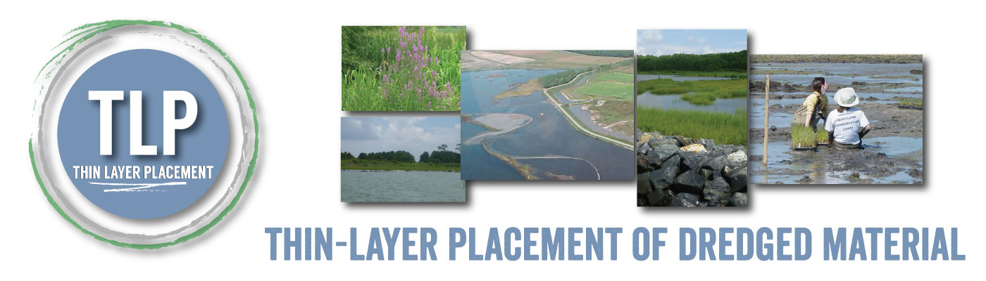
- Anacostia River Fringe Wetland Creation
- Blackwater National Wildlife Refuge Restoration
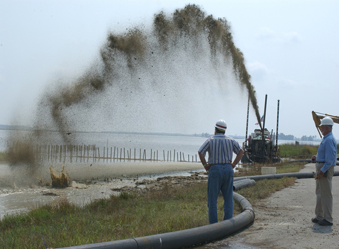
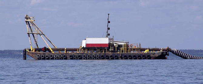
- Galveston GIWW Dredging West Bay
- Honga River and Tar Bay
- Ocean City Harbor Inlet and Sinepuxent Bay
- Port of Baltimore Channel System
- Pine Harbour Marina
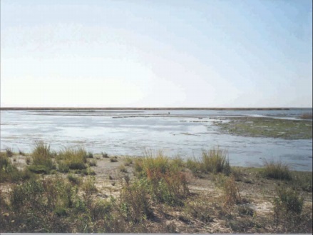
- Fowl River
- Gull Rock
- Jamaica Bay
- Mississippi Sound
- Pepper Creek
- Seal Beach
- Ward Cove
- Masonboro Island
- Silver Lake
- Mobile Bay
- Galveston GIWW, Laguna Madre
- Bayou Segnette Waterway
- High Salt Marsh in Georgia
- Freeman Creek, NC
- Sachuest Point National Wildlife Refuge
- John H. Chafee National Wildlife Refuge
- Southern Mississippi River Delta, LA
- Bayou Lafourche, LA
- Paul J. Rainey Wildlife Sanctuary
- Barataria Basin, LA
- Prime Hook National Wildlife Refuge
- Northern Mississippi River Delta, LA
- South Slough National Estuarine Research Reserve
- Commercial Township Salt Hay Farm
- IJburg Project
Case studies presently in the database can be accesses by clicking the links to the left or by scrolling down. Below each photos, users can link to a fact sheet, photo galleri, related reports and a map-based portal showing the location of the project. Users are encouraged to submit case studies or other references or tools for inclusion on the site.
To submit a case study for consideration, please complete the brief intake form found here. Your information will be reviewed and you will be registered on the site. Log-in credentials will be provided to enable you to input additional project information and upload related reports, data, and photos.
Project Description: As part of maintenance dredging, ecosystem restoration and flood control efforts, dredged material was used to create wetlands along the Anacostia. Two distinct placement areas were created, approximately4 and 13 acres in size, respectively. Both areas were protected by sheet piling (approximately 4300 linear feet); inside of the piling, biologs (approximately 10K linear feet) were installed to help stacking the dredged material. Notches were cut out of the sheet piling to allow tidal water to flow in and out, thereby feeding water to the wetlands. A marsh buggy was used during construction to grade the larger site. 74,000 CY of dredged material was placed hydraulically between the two sites. Wild rice and other hydrophytic species (350,000 plants) were planted after construction via plug, which were protected with 31,000 feet of goose fencing. The final cost of the project was $3.3M.
Project Description: This demonstration project was conducted for ecosystem restoration purposes in an area with a history of wetland loss. A thin layer of fine grained material was sprayed in 2, 1-2 acre sites and placed hydraulically. Hydroseeding was attempted by adding seeds to the dredged material spray. The material was placed in 2 lifts of small thickness which allowed the sites to become revegetated in a short period of time. Post placement monitoring indicated revegetation occurred immediately within the refuge and outside of the treatment area as well. The total project cost was $300,000.
Location:Galveston and Brazoria Counties, Galveston, TX, US
Year: 2012 (ongoing)
Project Type(s):Marsh nourishment/ Dredged material disposal
Project Description: Since the 1950’s, Galveston Bay has lost over 90% of its saltgrasses, an important and rare habitat in the bay. Two permitted placement areas were used for thin layer placement of maintenance dredged material to promote marsh restoration of intertidal habitat fringe marsh. The material was placed hydraulically in an unconfined placement area (mound building). The site will be monitored pre- and post-construction for seagrass and thin layer thickness.
Project Description: Use of maintenance dredged material for wetland creation purposes was the primary objective of the Honga River and Tar Bay projects. The material was placed hydraulically behind containment. Initially the material was contained with geotubes, but failure of the geotubes required later armoring with rock. The site was planted approximately one month post placement. The placed material was mainly composed of sand; therefore, bulldozers were used to keep moving the material and achieve final grading. Multiple placement events occurred at the site over a period of 8 years.
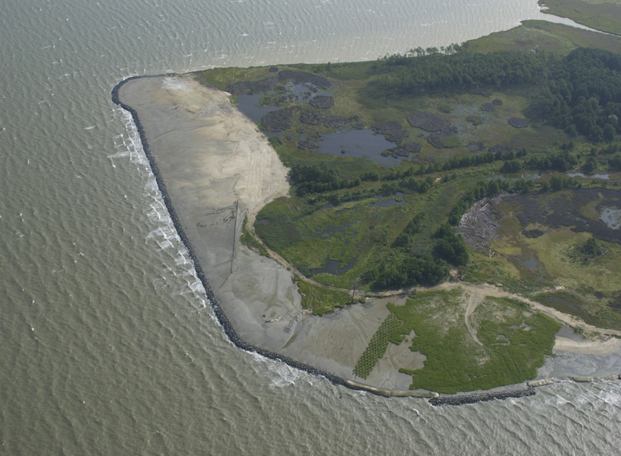
Project Description: Use of maintenance dredged material for wetland creation purposes was the primary objective of the Honga River and Tar Bay projects. The material was placed hydraulically behind containment. Initially the material was contained with geotubes, but failure of the geotubes required later armoring with rock. The site was planted approximately one month post placement. The placed material was mainly composed of sand; therefore, bulldozers were used to keep moving the material and achieve final grading. Multiple placement events occurred at the site over a period of 8 years.
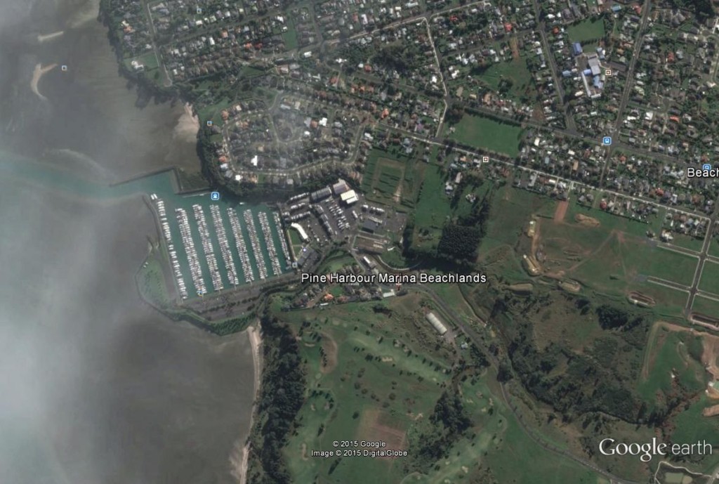
Location:Auckland, New Zealand
Year:1997
Project Type(s):Dredged material disposal
Project Description: In 1997, maintenance material removed from the Pine Harbour Marina channel was placed in a thin layer over an area of similar sediment character in the adjacent embayment. The granting authorities required a substantial monitoring program for the dredged and disposal areas. The main objectives of the monitoring efforts were to confirm that “the dredging activity does not cause the release of sediment into the surrounding environment at levels in excess of those naturally experienced”, and that “the marine disposal activity does not cause significant adverse effects upon the benthic organisms present in the embayment or cause the release of sediment into the environment surrounding the disposal site at levels in excess of those naturally experienced”. This project focused on the monitoring aspects of the of the dredged and disposal areas before, during and after each annual dredging operation.
Location:Mobile County, Mobile, AL, US
Year: 1986
Project Type(s):Dredged material disposal
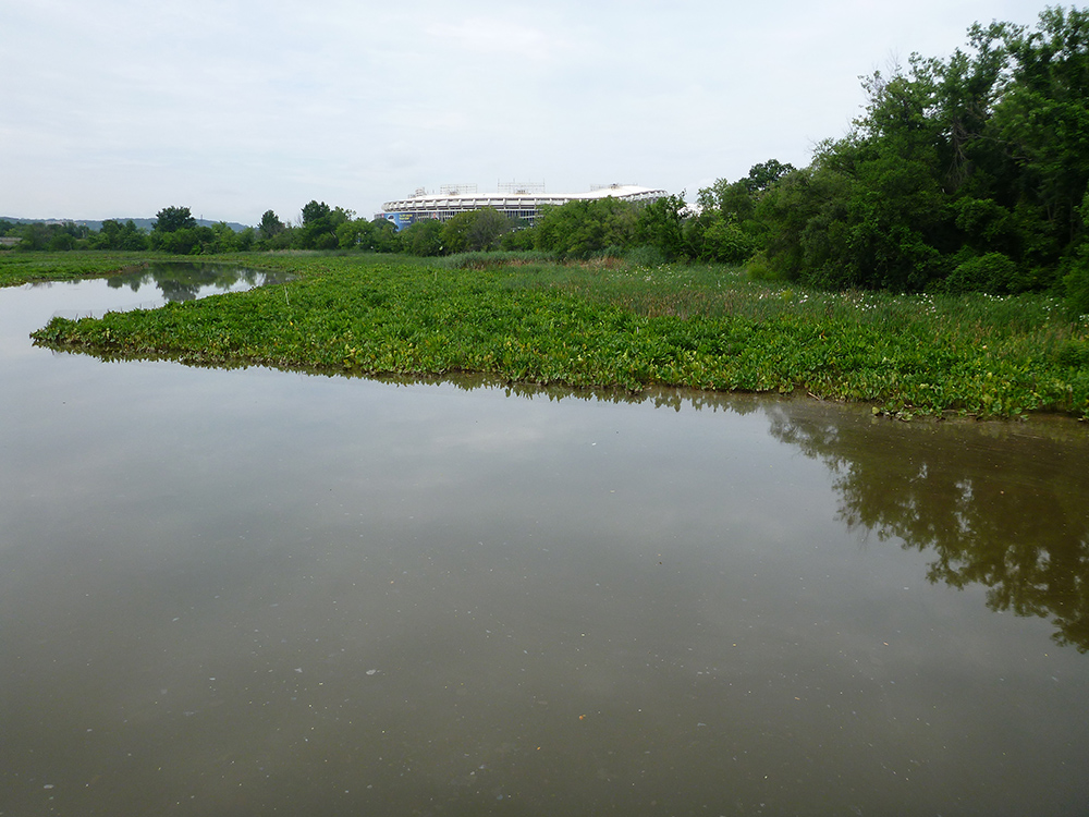
Project Description: Material dredged from the Fowl River channel for maintenance purposes was typically placed open water and in wetland areas, however, the lack of adequate disposal areas lead to the use of open water thin layer placement in 1986. The main purpose of this project was to determine the physical and biological impacts caused by thin layer placement. Approximately 190,000 CY of dredged material were placed in a 6 in. thin-layer over a 240-acre open-water disposal area. The material was dredged hydraulically with a 6-blade cutterhead at 487-497 CY/hr and placed in the disposal area with a wing-mounted baffle plate connected to the pipeline slurry discharge. The dredging operations were completed within one month. A monitoring program was implemented at the site which was designed to monitor the dredging and disposal areas pre, during, and post-dredging/disposal.
Location:Hyde County, Swanquarter, NC, US
Year: 1982
Project Type(s):Dredged material disposal/marsh nourishment
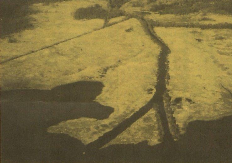
Project Description: The objective of this project was to evaluate physical and environmental effects of dredge material placed 9 years earlier in two different marsh areas located in Gull Rock, NC. Approximately 10,000 to 20,000 CY of dredged material consisting of clay, silt, and fine sand were sprayed on one site with a 6-in. pipeline that split to feed two 3-in. independent discharge nozzles. Sediment layer thickness ranged from 0.4 to 4 in., with an average thickness of about 2 in. Additional material was sprayed on a 2nd site site in a thin layer ranging from 0.4 to 8 in., with an average thickness of approximately 4 in. Nine years after thin layer placement, the canal and marsh site were assessed to capture the long-term effects of the placement activities.
Location:Queens County, New York City, NY, US
Year: 2000
Project Type(s):Marsh nourishment/habitat restoration
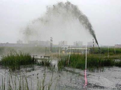
Project Description: Big Egg Marsh is a degraded marsh site located in the southern side of Jamaica Bay Sediment subsidence, sea level rise, erosion, plant mortality, and the bay isolation all contributed to marsh loss, resulting in transition of the site from Smooth Cordgrass to a bare mudflat. The main objectives of this project were to evaluate the effectiveness of a new method of sediment transfer and placement to increase marsh elevation and the growth of marsh vegetation through thin layers of placed sediment. In September 2003, approximately 8,000 CY of dredged material was placed on the surface of a 2-acre area using a 10 cm diameter nozzle (high-pressure spray). The material placement was guided by polyvinylchloride pipes arranged in a grid pattern. The thin layer placement thickness was generally 8 in.; however, a maximum of 17 in. was placed in certain areas that required more material in order to be above the reference plane. The project site along with a 2-acre control site was monitored one year pre and post-construction.
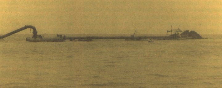
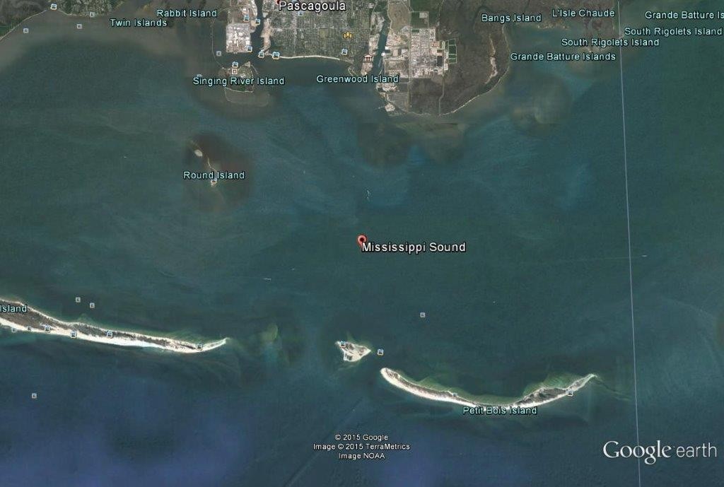
Location:Hancock, Harrison, Jackson and Mobile (AL) Counties, Waveland/Dauphin Island, MS/AL, US
Year: 1992-1993
Project Type(s):Dredged material disposal
.
Project Description: Mississippi Sound channel improvements required removal of 1 MCY from the channel (maintenance material) that were subsequently placed in a thin layer with thickness = 12 in. in three, 300-acre disposal areas along the west side of the channel. Similarly, 1 MCY of new work material was removed and placed in a thin layer with thickness = 12 in. in three, 300-acre disposal areas along the east side of the channel. The material was placed with a spreader barge in each disposal area during three separate disposal events. Each disposal area was monitored for water quality and benthic community responses predisposal, during disposal, short-term postdisposal, and long-term after post disposal.
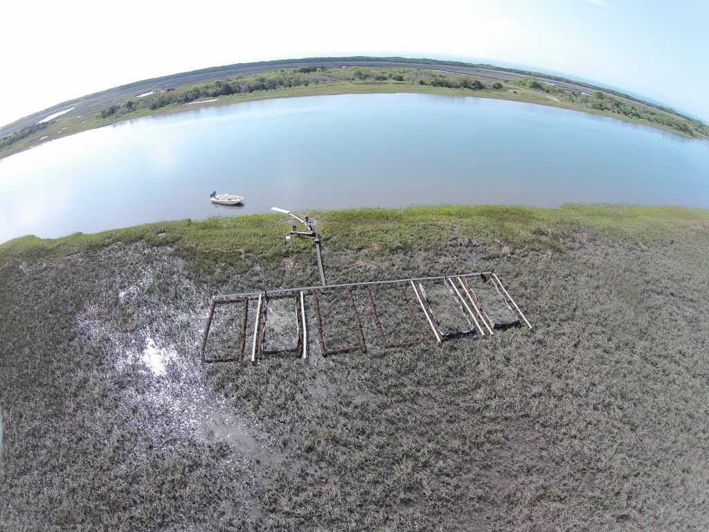
Location: Sussex County, Dagsboro, DE, US
Year: 2013
Project Type(s): Marsh restoration
Project Description: Dredged material from maintenance dredging at Pepper Creek was used for rebuilding a 25 acre area of tidal marsh adjacent to Vines Creek Marina. The main purpose of the project was to mitigate the effects of marsh subsidence and sea level rise, by placing a thin layer of dredged material over the marsh. The material was dredged hydraulically and pumped to a barge located on the shoreline of the marsh. Approximately 35,000 CY of dredged material was sprayed on the marsh surface at 3,000 gal/min using a 4-in. high-pressure nozzle. The thin layer thickness ranged from 1 to 6 in. The dredging and placement operations were conducted during the winter to minimize negative impacts to the fish communities. The total project cost was $125,000. The placement area was monitored daily and is still being monitored for layer thickness, vegetation, and biological and chemical conditions.
Location: Orange County, Seal Beach, CA, US
Year: 2016
Project Type(s): Marsh nourishment/habitat restoration
Project Description: The Seal Beach NWR’s cordgrass dominated salt marsh habitat has been adversely affected by subsidence and sea level rise. The main objective of the Seal Beach project is to improve habitat quality and facilitate sea level rise (SLR) adaptation. An 8 to 10 in. thin layer of dredged material will be placed over 10 acres of a low elevation salt marsh in Oct-Jan 2015/2016. Approximately 10,000 to 13,500 CY of clean dredged material from the Main Channel West of Sunset Harbor will be placed on the site via rainbow sprayer, open pipe, or end-of-pipe baffle impingement. The dredged material placement is expected to take from 4 to 6 weeks. Monitoring of vegetation, sediment dynamics, elevation, invertebrates and birds communities, and wetland biogeochemistry is planned pre and post placement.
Location: Ketchikan Gateway County, Ketchikan, AK, US
Year: 2001
Project Type(s): Sediment remediation/thin layer capping
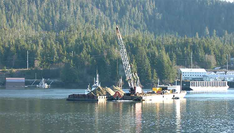
Project Description: Ward Cove is a 250 acre site located on the north side of Tongass Narrows, 5 miles north of Ketchikan, AK. 80 acres of the cove were designated as an area of concern (AOC) by the USEPA due to historical releases from the Ketchikan Pulp Company. Contaminants of concern included ammonia, 4-methylphenol, and sulfide. USEPA determined that the contaminated sediments were not toxic to human or wildlife (USEPA, 2000), however, the site posed a risk for benthic macroinvertebrates. The primary objectives of the remediation efforts were to reduce the toxicity of the contaminated sediments and to stimulate colonization of the remediated areas by benthic macroinvertebrates (Becker et al. 2009). In 2001, approximately 24,000 CY of material were placed in a 6 to 12 in. thin layer cap to enhance the natural recovery of 28 acres of contaminated sediments. The remaining 52 acres were remediated using monitored natural recovery. The material was placed with a derrick barge and modified cable arm re-handling bucket, which resulted in the most consistent and uniform placement method in the deep water of the cove.
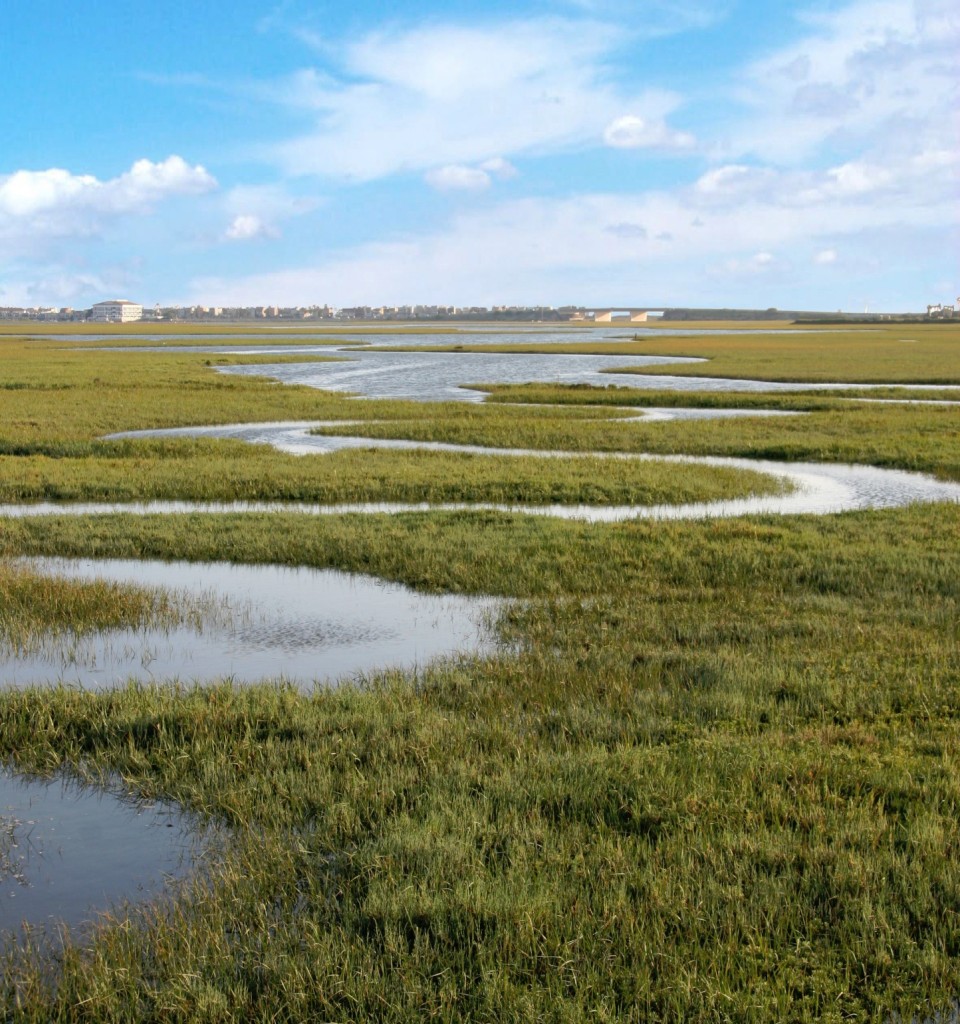
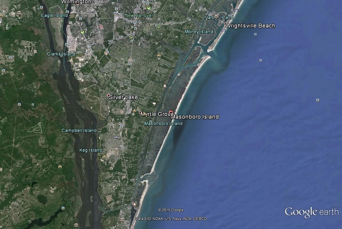
Location: New Hanover County, Wilmington, NC, US
Year: 2000
Project Type(s): Marsh nourishment
Project Description: The purpose of this project was to investigate the effects of placing dredged material on the surface of a back barrier tidal salt marsh located in Masonbro Island, NC, where sediment accretion is insufficient to maintain elevation in equilibrium with sea level rise. A pilot scale study was conducted in a 1,800 ft^2 area consisting of 2 non-deteriorated and 2 deteriorated sites of 450 ft2 each. Approximately 11 CY of dredged material were placed during high tide at depths varying gradually from 0 to 10 m across each site, to reduce adverse effects on vegetation, simulate slurry disposal, and promote uniform distribution. Monitoring of thin layer thickness, plant density, benthic community assemblage and abundance, and oxidation reduction potential was conducted every other month for approximately a year.
Location: Berkshire County, Pittsfield, MA, US
Year: 2006/2013
Project Type(s): Sediment remediation/thin layer capping
Project Description: Historic discharges of PCBs and other chemicals from a GE facility resulted in moderate to high concentrations of PCBs in the Silver Lake sediments. 400 CY of “hot spot” sediment was dredged, in addition to near-shore sediment, and contaminated bank soil. A silty sand-based cap was placed on the entire bottom of the lake. A pilot scale project was conducted in 2006 which was used to develop the conceptual design of the cap and the final work plan. Full-scale remediation initiated in the summer of 2012 and was completed in December 2013. Multiple capping systems were incorporated in different areas of the site. The majority of the lake bottom was capped with a 14-in. thick layer. The near-shore portion of the lake was capped with a non-woven geotextile followed by a 10-in. thick layer of cap material (sand and topsoil with a minimum in-place TOC of 0.5%), and an armor stone layer. The placement system consisted of a conveyor system, modified mix tank, make-up water and slurry pumps, 1,800-foot slurry pipeline, floating barge structures, and a custom-designed slurry dissipator barge. In 2014, GE initiated inspection, monitoring and maintenance activities at the site to ensure that the capping systems were functioning effectively.
Location: Mobile County, Mobile, AL, US
Year: 2012/2014
Project Type(s): Sediment budgeting/Dredged material disposal
Project Description: Thin layer placement of dredged material was planned for multiple placement areas that are historical open-water disposal areas used prior 1986. Thin layer placement benefits channel dredging operations, keeps sediment in the system, provides faster recovery for bay-bottom benthic communities, and has negligible impact on benthic ecology. Emergency in-bay thin layer placement was approved in 2012. Approximately 9 MCY dredged material were placed in a thin layer (thickness smaller than 12 in.) using a hydraulic cutterhead. A monitoring and modeling program were established to evaluate short and long term fate and transport of in-bay thin layer placement. The results of this program indicated that thin layer placement of dredged material in the bay will have negligible impact, hence a long-term in-bay thin layer placement program was approved in 2014. In 2014, 1MCY of dredged material was placed in a thin layer in-bay using a spill barge with a system of winches and a continuous GPS tracking system. Both of these thin layer placement efforts resulted in significant savings in dredging costs, less erodible material in the sediment surface, and a quick recovery of the benthic community.
Location: Nueces, Kenedy, Kleberg, Willacy and Cameron Counties, Multiple cities in the South Texas Gulf Coast, TX, US
Project Type(s): Marsh nourishment/ Dredged material disposal
Project Description: The Laguna Madre section of the GIWW requires regular maintenance dredging, hence the Dredged Material Placement Plan (DMPP) is considering thin layer placement for three placement areas (PAs). These PAs will be managed primarily for reducing impact to nearby seagrass habitat, bird use, or vegetation control. The DMMP assumes that dredged material placement activities will use a dispersing or energy dissipating device to spread the material in a thin layer to decrease the chance of burying seagrass too deep to recover and prevent causing scour holes when the material exits the discharge pipe. Long term impacts to seagrass from being covered with a thin layer of dredge material would be minimized if the material is placed in the winter months when the seagrass is photosynthetically inactive (Galveston Bay Foundation 2012).
Location: Jefferson Parish, New Orleans, LA, US
Year: 2010
Project Type(s): Sediment remediation/thin layer capping
Project Description: A pilot scale study was conducted in 2010 at Bayou Segnette Waterway to evaluate thin layer placement capacity in floating marsh areas with lower elevation as a function of spray distance. Visual inspection of the 2010 thin layer placement sites indicated that the areas appeared to be thriving one growing season after placement. Results obtained from this study showed that thin layer capacity is dependent on the location of the discharge pipe and the placement thickness of the material. If the discharge pipe is located at the top of the spoil bank (as assumed) most of the material can be placed directly on the marsh. Thin layer placement capacity ranged from 12,000 (50 ft spray distance, 0.79 in. thickness) to 143,000 CY (300 ft spray distance, 1.57 in. thickness). The success of thin layer placement on floating marsh depends on the ability of the marsh to maintain buoyancy during and after placement, and the resiliency of marsh vegetation which are influenced by the placed material thickness and physical characterization.
Location: Glynn County, Brunswick, Brunswick, GA, US
Year: 1978
Project Type(s): Dredged material disposal, marsh nourishment
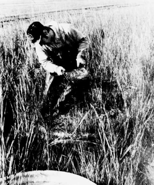
Project Description: The purpose of this project was to evaluate the recovery response of salt marsh vegetation and impact of selected species of crabs and snails upon thin layer placement of dredged material. A high, intertidal, homogenous Spartina alterniflora marsh located in Glynn County, Georgia was selected to conduct this pilot research project in the 1970s. The experiments were conducted inside corrugated metal pipes of various length that were inserted into the marsh substrate to a depth of 1.2 m to ensure that only the enclosed area would be influenced by dredged material placement. Six different dredged material thicknesses ranging from 8 cm (3 in.) to 91 cm (36 in.), three different dredged material types (sand, clay, and sand and clay mixture), and three different times for material placement (February, July, and November) were selected for the testes conducted in this study. The results from this pilot scale study indicated that marsh elevation could be altered through thin layer placement of dredged material up to 23 cm (9 in.) without loss of the functional values of the ecosystem and environment.
Location: Onslow County, Jacksonville, NC, US
Year: 2017 (ongoing)
Project Type(s): Marsh nourishment
Project Description: The purpose of this demonstration project is to provide the foundation for use of thin layer placement of dredged material in similar location by developing a list of parameters and models predictions that are necessary for applying thin layer placement of dredged material to coastal wetlands. The project site is located adjacent to the AIWW as it traverses MCBCL behind the Onlsow Beach barrier island. The results of the Coastal Wetland monitoring program indicate that the marsh platform at the project site is 20-25 cm below “optimal” growth elevations for Spartina alterniflora. Approximately 5 to 10 cm of dredged material were placed in three experimental plots in March/April 2017. The site was monitored before thin layer implementation and will be monitored every 2 months for 2 years.
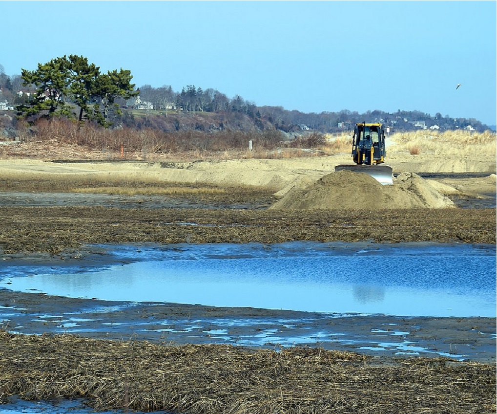
Location: Newport County, Middletown, RI, US
Year: 2015 (ongoing)
Project Type(s): Habitat restoration
Project Description: The Maidford River Saltmarsh Restoration Project encompasses 11 acres of tidal salt marsh in the Sachuest Point National Wildlife Refuge, RI where elevation of the marsh prevented proper drainage at low tide. Eleven thousand cubic yards of sand were spread across the marsh using mechanical methods to target marsh elevation ranging between 2.2 and 2.3 NAVD88. This target elevation range is on the high end of the elevation range for Spartina patens. A thin layer of sand ranging from 2.5 to 30 cm was placed in the marsh to achieve these target elevations. The addition of sand to the marsh has improved marsh drainage, alleviated flooding of nearby roads, and improved habitat necessary for the growth of salt marsh plants critical for Saltmarsh Sparrow nesting. Plugs of marsh grasses were planted in May 2016 in locations were thin layer thickness was greater than 10 cm.
Location: Washington County, Narragansett and South Kingstown, RI, US
Year: 2016 (ongoing)
Project Type(s): Habitat restoration
Project Description: This restoration project encompasses 14 acres of degraded tidal marsh on the eastern shore of the Narrow River Estuary, RI. A combination of sea level rise and storm impacts from Hurricane Sandy resulted in the degradation of this tidal salt marsh. The addition of dredged material to 14 acres of degraded salt marsh occurred in the winter of 2016-2017. Areas of marsh with signs of stressed vegetation and expanding pond areas were targeted to receive sediment. The sediment was obtained from channel dredging for eelgrass restoration in a nearby tidal flat. The sediment was mainly composed of fine sands, with some fines present. Sediment was placed on the marsh surface using mechanical methods to reach target elevations for high marsh habitat. Extensive monitoring prior to restoration and construction was completed and will continue as the salt marsh recovers.

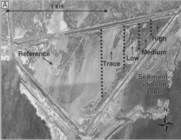
Location: Plaquemines Parish, Venice, LA, US
Year: 1992
Project Type(s): Marsh nourishment
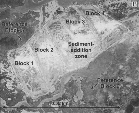
Project Description: The salt marsh receiving dredged material is located 106 km southeast of New Orleans, LA on the southern portion of the modern Mississippi Delta, near the town of Venice, LA. The salt marsh was degraded due to a combination of a high rate of sea level rise, subsidence, and sediment deficiencies as levees prevented regular sediment supply and flooding from the Mississippi River. The salt marsh received sediment additions as a slurry in January, 1992. The sediment addition resulted in a gradient of sediments depths across the marsh surface. This gradient was used to evaluate the effect of sediment depth on marsh response. These sediment depths were: reference (no sediment addition), trace sediment addition (< 2 cm), < 15 cm sediment addition, 15-30 cm sediment addition, and > 30 cm sediment addition. The addition of sediment to the marsh surface at intermediate depths reduced vegetation stress associated with prolonged inundation by increasing soil aeration and reducing the accumulation of toxic sulfides. After 15 years, the marsh area that received intermediate sediment depths were stable and resilient to experimental disturbances, suggesting sediment additions to degraded marshes at appropriate depths is a sustainable restoration technique
Location: Lafourche Parish, Leeville, LA, US
Year: 2002
Project Type(s): Marsh nourishment
Project Description: Seven and a half hectares of salt marshes south of Leeville, LA received dredged material in 2002. This marsh experienced a large scale disturbance in 2000 as a result of a record drought. The drought caused the sudden dieback of Spartina alterniflora. In some areas the marsh did not re-vegetate after the disturbance and was converted to mudflats. Dredged material was placed on previously vegetated areas to promote vegetation regrowth. Dredged material was placed on the marsh using the sediment-slurry technique, which utilizes a high water to sediment ratio to spread dredged material across the marsh surface. Seven years after placement, the marshes that received dredged material had equivalent total aboveground biomass, live biomass, stem density, and height of Spartina alterniflora comparable to the reference marsh.
Location: Vermillion Parish, LA, US
Year: 2008
Project Type(s): Marsh nourishment
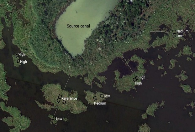
Project Description: In July 2008, dredged material was mechanically pumped from a nearby oil canal into 20, 3 m by 4 m contained areas within the marsh located in the Paul J. Rainey Wildlife Sanctuary, LA. Four different sediment depths were achieved by using the high water to sediment ratio sediment-slurry technique for spreading the dredged material. Sediment was applied to depths of either no sediment (control), 0-10 cm, 10-15 cm, or 15-20 cm. After three years, elevation gains of 3 cm were seen in the highest deposition areas as a result of consolidation and compression of the organic material below. Increased plant productivity due to nutrient additions was observed despite the small elevation gain. In addition, thicker thin layer placement applications onto the marsh resulted in a decrease in sulfide concentration and an increase in sulfate concentration.
Location: Lafourche Parish, LA, US
Year: 1986
Project Type(s): Marsh nourishment
Project Description: In 1986, approximately 17 square meters of salt marshes located in Barataria Basin, LA received sediment applications at depths of 2-3 cm or 4-5 cm. The main purpose of this project was to ameliorate vegetation stress from increased inundation and accumulation of toxic sulfides. The applied sediment consisting of 40% fine sand, 28% coarse-fine silt, and 32% clays and organics was manually applied to the marsh surface from a nearby location. Aboveground biomass and vertical marsh accretion was assessed between reference marshes and marshes that received sediment. The addition of sediment to the marsh surface increased plant productivity, and decreased inundation due to an increase in elevation and nutrient supply.
Location: Sussex County, Milton, DE, US
Year: 2016 (ongoing)
Project Type(s): Habitat restoration
Project Description: This tidal marsh restoration project encompasses 4,000 acres of degraded tidal marsh and barrier beach located within a formerly impounded wetland system. The site’s salt marsh habitat has been adversely affected by 30 years of impounded freshwater drowning marsh plants. In addition, storm surge from Hurricane Sandy and other storms caused a series of breaches along the impoundments. This tidal marsh restoration project was completed in September 2016 by dredging 30 miles of channels. Sediments from the channel dredging were sidecast from the dredge to elevate open water areas in thin layers to allow plant growth. Spartina patens and Spartina alterniflora plugs were planted in exposed mudflats after channel restoration was completed. Restored marshes were covered with new vegetation after one growing season in many areas where there was shallow open water prior to restoration.

Location: Plaquemines Parish, Venice, LA, US
Year: 1996
Project Type(s): Marsh nourishment
Project Description: The salt marsh that received dredged material is located near Venice, LA on the northern portion of the modern Mississippi River Delta. Marshes in this area experience high rates of sea level rise, subsidence, and anthropogenic disturbances including oil/gas exploration. The use of thin layer placement of dredged material was intended to restore elevations in shallow open water areas to a suitable elevation for emergent marsh and to assess the impact of the spray dredging technique on vegetated marsh. The salt marsh received thin sediment additions from a nearby canal in July 1996 utilizing the spray (rainbow) dredging technique. The thickness of sediment application was 23 ± 5 mm on the marsh and 116 ± 11 mm in the shallow open water areas. The addition of sediment increased the marsh elevation, which allowed emergent vegetation to colonize the once open water areas via rhizome growth from the edge of the marsh. Overall, the emergent marsh and shallow open water areas responded positively to thin layer placement.

Location: Cooks County, Charleston, OR, US
Year: 1996
Project Type(s): Habitat restoration
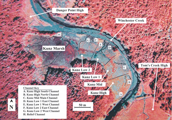
Project Description: Five acres in the South Slough National Estuarine Research Reserve, Oregon received dredged material to mitigate loss of elevation due to diking. Diking of the marsh excluded tidal flooding while ditches redirected freshwater off the marsh. The combination of reduced sedimentation and soil oxidation resulted in the subsidence of the soil surface in Kuntz Marsh. The addition of sediment to the 5 acre marsh occurred in 1996 by excavating the top 15 to 30 cm of existing marsh soil and vegetation; this material was stockpiled for redistribution once the marsh surface was elevated through thin layer placement. Approximately 10,000 cubic meters of dredged material was excavated from the Kunz Marsh dike and mechanically spread across the marsh to the desired marsh elevation. The stockpiled marsh soil was redistributed over the dredged material. Three marsh elevations were established: high, middle, and low intertidal marsh elevations to assess the formation of tidal channels. The mid marsh elevation vegetated quickly and developed tidal channels at a rate that also enhanced sediment accretion on the marsh suggesting marsh elevation within the tidal prism and slope of the marsh are important contributing factors to successful marsh restoration.
Location: Cumberland County, Commercial Township, NJ, US
Year: 1996
Project Type(s): Habitat restoration
Project Description: Forty two hectares of diked marshes were restored at the Commercial Township Salt Hay Farm, DE. The combination of reduced sedimentation, soil compaction from heavy machinery, and soil oxidation resulted in the subsidence of the marsh surface. The addition of sediment to low elevation areas within the restoration site occurred in 1996 by utilizing dredged material from the site construction, mainly from excavation of channels and breaches in the dike. The addition of dredged material to areas of low elevation resulted in raising the marsh elevation greater than mean high water to support high marsh habitat. After three years, the Spartina alterniflora cover was 10% of the marsh surface at the Commercial Township Salt Hay. The slow recovery of the vegetation may be attributed to lower elevations than necessary for Spartina alterniflora to vegetate.
Location: IJburg, Amsterdam, The Netherlands
Year: 1995
Project Type(s): Island creation
Project Description: The main purpose of this project was to create artificial island in IJburg that will provide new housing in Amsterdam. The main issue associated with the site was that the subsoil is very soft hence it would be challenging to place the material without removing the soft subsoil or placing a large amount of geotextile on top of the subsoil which could result in high construction costs. Hence, the material to be placed for island creation needed to be placed in thin layers to prevent instability issues in the site. Sand dredged from Lake Markermeer, which was located 25 km (15 mi) from the reclamation site, was placed in thin layers of 50 cm (20 in.) using a computer-controlled spray pontoon for the first three layers and conventional hydraulic placement for the rest of the layers. The spray pontoon was utilized to ensure placement of a constant thickness to avoid load differences and instability. Each layer was allowed to consolidate for 4 weeks to ensure local stability of the subsoil. The total thickness of material placed for island creation is 5.2 m (16.5 ft). Prior to removing the sand from the lake, approximately 9,700,000 cubic meters (12,687,121 cubic yards) of clay, 8 m (26 ft) thick layer, had to be removed by cutter suction and placed back in the lake using the “clay relocation method”..
